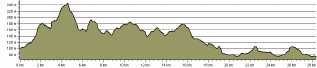
 The above picture is the route profile for the Hutchinson Way footpath, copied from the LDWA site . The footpath is described as 17-18 miles or rural, urban -type of trail.
I've only tried it once before; tales of me failing and sitting, sobbing gently on the base of Lilleshall Monument are dotted around t'internet. I set out this morning, slightly apprehensive but eager not to repeat that sad event.
Ok. So the run starts at Wellington pool, but quickly climbs up to the Ercall and then climbs some more into the Limekiln Woods before crossing the golf course and then deeper into Limekiln Woods before coming out at Short Wood. First minor problem here when I was confronted by a barbed-wire fence, thankfully I was tall enough to get over with negligible damage.
The next bit took me past the travellers' camp at Lawley before getting on to some tarmac, going via the Rock and eventually pitching up at Telford Centre. It's quite surreal being away from it all in one minute then running past the cinema and office blocks the next. But all was going well.
The next bit was via the railway station and up to Priorslee and the Flash (pool), here's where the leaflet/map proved to be a bit rubbish and local knowledge took over. How you can find the route just using the map, heaven knows (more later on this!)
Once at the top of Limekiln Bank, it was down the hill and into the Granville Park, along the trails again and across to Lilleshall over the fields. All was going well, maybe I should have quit then. Oh, hang on, that IS where I quit last time! I knew I had to be on the Incline, I knew where I was but I insisted on following the HW map/directions. Bad move. Not clear signage left me climbing another fence, then stile, then struggling across a field of Oilseed Rape (thankfully not in flower) until I got to another grassy field. Easy? no. the grass was knee-high, my feet were soaked. Eventually I got onto the incline and picked up the more familiar path along the old canal, scaring the sheep, feeling good.
This path soon became almost impassable too though, being overgrown with brambles, scratching my legs and reducing me to a jog/walk/stumble. Eventually I made it back to the woods and some running relief.
The map then directed me on to the A518 and then up Pitchcroft Lane (nasty touch, definitely an unnecessary climb) before crossing more nettles/ long grass and crossing the A518 again. On the other side I could almost taste the finish but the path was completely overgrown and I soon found myself stuck in a long grassy field and then lost. I retraced my steps and decided the best course was to go into Church Aston and pick up the trail there. From then on it was easy, though I was a bit tired I was soon trotting down the High St. I realised the finish was on Stafford St. Car Park so a quick detour via Waitrose was called for!
Stats: 18.64 miles, over 3 hours . 3.33 on the clock, but considerable time taken up with detours and some walking/falling over. Had no problem with the distance though. The course is, to be honest, very contrived in the final few miles, poorly signed and poorly maintained. But it's done now...!
The above picture is the route profile for the Hutchinson Way footpath, copied from the LDWA site . The footpath is described as 17-18 miles or rural, urban -type of trail.
I've only tried it once before; tales of me failing and sitting, sobbing gently on the base of Lilleshall Monument are dotted around t'internet. I set out this morning, slightly apprehensive but eager not to repeat that sad event.
Ok. So the run starts at Wellington pool, but quickly climbs up to the Ercall and then climbs some more into the Limekiln Woods before crossing the golf course and then deeper into Limekiln Woods before coming out at Short Wood. First minor problem here when I was confronted by a barbed-wire fence, thankfully I was tall enough to get over with negligible damage.
The next bit took me past the travellers' camp at Lawley before getting on to some tarmac, going via the Rock and eventually pitching up at Telford Centre. It's quite surreal being away from it all in one minute then running past the cinema and office blocks the next. But all was going well.
The next bit was via the railway station and up to Priorslee and the Flash (pool), here's where the leaflet/map proved to be a bit rubbish and local knowledge took over. How you can find the route just using the map, heaven knows (more later on this!)
Once at the top of Limekiln Bank, it was down the hill and into the Granville Park, along the trails again and across to Lilleshall over the fields. All was going well, maybe I should have quit then. Oh, hang on, that IS where I quit last time! I knew I had to be on the Incline, I knew where I was but I insisted on following the HW map/directions. Bad move. Not clear signage left me climbing another fence, then stile, then struggling across a field of Oilseed Rape (thankfully not in flower) until I got to another grassy field. Easy? no. the grass was knee-high, my feet were soaked. Eventually I got onto the incline and picked up the more familiar path along the old canal, scaring the sheep, feeling good.
This path soon became almost impassable too though, being overgrown with brambles, scratching my legs and reducing me to a jog/walk/stumble. Eventually I made it back to the woods and some running relief.
The map then directed me on to the A518 and then up Pitchcroft Lane (nasty touch, definitely an unnecessary climb) before crossing more nettles/ long grass and crossing the A518 again. On the other side I could almost taste the finish but the path was completely overgrown and I soon found myself stuck in a long grassy field and then lost. I retraced my steps and decided the best course was to go into Church Aston and pick up the trail there. From then on it was easy, though I was a bit tired I was soon trotting down the High St. I realised the finish was on Stafford St. Car Park so a quick detour via Waitrose was called for!
Stats: 18.64 miles, over 3 hours . 3.33 on the clock, but considerable time taken up with detours and some walking/falling over. Had no problem with the distance though. The course is, to be honest, very contrived in the final few miles, poorly signed and poorly maintained. But it's done now...!
Sunday, 17 June 2012
The Hutchinson Way, way, way
The above picture is the route profile for the Hutchinson Way footpath, copied from the LDWA site . The footpath is described as 17-18 miles or rural, urban -type of trail.
I've only tried it once before; tales of me failing and sitting, sobbing gently on the base of Lilleshall Monument are dotted around t'internet. I set out this morning, slightly apprehensive but eager not to repeat that sad event.
Ok. So the run starts at Wellington pool, but quickly climbs up to the Ercall and then climbs some more into the Limekiln Woods before crossing the golf course and then deeper into Limekiln Woods before coming out at Short Wood. First minor problem here when I was confronted by a barbed-wire fence, thankfully I was tall enough to get over with negligible damage.
The next bit took me past the travellers' camp at Lawley before getting on to some tarmac, going via the Rock and eventually pitching up at Telford Centre. It's quite surreal being away from it all in one minute then running past the cinema and office blocks the next. But all was going well.
The next bit was via the railway station and up to Priorslee and the Flash (pool), here's where the leaflet/map proved to be a bit rubbish and local knowledge took over. How you can find the route just using the map, heaven knows (more later on this!)
Once at the top of Limekiln Bank, it was down the hill and into the Granville Park, along the trails again and across to Lilleshall over the fields. All was going well, maybe I should have quit then. Oh, hang on, that IS where I quit last time! I knew I had to be on the Incline, I knew where I was but I insisted on following the HW map/directions. Bad move. Not clear signage left me climbing another fence, then stile, then struggling across a field of Oilseed Rape (thankfully not in flower) until I got to another grassy field. Easy? no. the grass was knee-high, my feet were soaked. Eventually I got onto the incline and picked up the more familiar path along the old canal, scaring the sheep, feeling good.
This path soon became almost impassable too though, being overgrown with brambles, scratching my legs and reducing me to a jog/walk/stumble. Eventually I made it back to the woods and some running relief.
The map then directed me on to the A518 and then up Pitchcroft Lane (nasty touch, definitely an unnecessary climb) before crossing more nettles/ long grass and crossing the A518 again. On the other side I could almost taste the finish but the path was completely overgrown and I soon found myself stuck in a long grassy field and then lost. I retraced my steps and decided the best course was to go into Church Aston and pick up the trail there. From then on it was easy, though I was a bit tired I was soon trotting down the High St. I realised the finish was on Stafford St. Car Park so a quick detour via Waitrose was called for!
Stats: 18.64 miles, over 3 hours . 3.33 on the clock, but considerable time taken up with detours and some walking/falling over. Had no problem with the distance though. The course is, to be honest, very contrived in the final few miles, poorly signed and poorly maintained. But it's done now...!
Subscribe to:
Post Comments (Atom)
No comments:
Post a Comment